


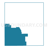
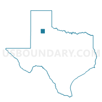
Voting District 0001, Floyd County, Texas
About
Outline

Summary
| Unique Area Identifier | 673064 |
| Name | Voting District 0001 |
| County | Floyd County |
| State | Texas |
| Area (square miles) | 221.53 |
| Land Area (square miles) | 221.41 |
| Water Area (square miles) | 0.12 |
| % of Land Area | 99.94 |
| % of Water Area | 0.06 |
| Latitude of the Internal Point | 33.93349700 |
| Longtitude of the Internal Point | -101.43648880 |
Maps

Graphs
Select a template below for downloading or customizing gragh for Voting District 0001, Floyd County, Texas


Neighbors
Neighoring Voting District (by Name) Neighboring Voting District on the Map
- Voting District 0011, Crosby County, TX
- Voting District 0018, Floyd County, TX
- Voting District 0023, Floyd County, TX
- Voting District 0024, Floyd County, TX
- Voting District 0039, Crosby County, TX
- Voting District 0041, Lubbock County, TX
- Voting District 0213, Hale County, TX
- Voting District 0214, Hale County, TX
Top 10 Neighboring County Subdivision (by Population) Neighboring County Subdivision on the Map
- Plainview CCD, Hale County, TX (29,098)
- Idalou CCD, Lubbock County, TX (4,132)
- Floydada CCD, Floyd County, TX (3,824)
- Lockney CCD, Floyd County, TX (2,622)
- Ralls CCD, Crosby County, TX (2,346)
- Crosbyton CCD, Crosby County, TX (2,234)
- Lorenzo CCD, Crosby County, TX (1,479)
- Petersburg CCD, Hale County, TX (1,430)
Top 10 Neighboring Place (by Population) Neighboring Place on the Map
Top 10 Neighboring Unified School District (by Population) Neighboring Unified School District on the Map
- Plainview Independent School District, TX (28,985)
- Floydada Independent School District, TX (3,955)
- Lockney Independent School District, TX (2,405)
- Ralls Independent School District, TX (2,334)
- Crosbyton Consolidated Independent School District, TX (2,248)
- Lorenzo Independent School District, TX (1,575)
- Petersburg Independent School District, TX (1,431)
Top 10 Neighboring State Legislative District Lower Chamber (by Population) Neighboring State Legislative District Lower Chamber on the Map
Top 10 Neighboring State Legislative District Upper Chamber (by Population) Neighboring State Legislative District Upper Chamber on the Map
Top 10 Neighboring 111th Congressional District (by Population) Neighboring 111th Congressional District on the Map
Top 10 Neighboring Census Tract (by Population) Neighboring Census Tract on the Map
- Census Tract 9506, Hale County, TX (4,828)
- Census Tract 9506, Floyd County, TX (3,824)
- Census Tract 9505, Floyd County, TX (2,622)
- Census Tract 9502, Crosby County, TX (2,346)
- Census Tract 9501, Crosby County, TX (2,234)
- Census Tract 101.01, Lubbock County, TX (1,656)
- Census Tract 9503, Crosby County, TX (1,479)
- Census Tract 9508, Hale County, TX (1,430)